
Have you ever wondered Kaveri river belt (Trichy and Delta areas) do not have ancient ruins like Vaigai (Keeladi) and Thamirabarani (Adichanallur ) dated to be 500 BC or earlier? Kaveri is such a major river system and yet it doesn’t have no major excavation sites dating 500 BC in the delta region.
The answer to the question is that Kaveri was flowing in Madras and Pondicherry before 500 BC.
Most of the details quoted in this blog are from papers/ books of S.M.Ramasamy and B.Arunachalam which are cited in the reference.
About 65 million years ago, the South India has undergone epierogenic movements (vertical movement of continent forming mountains, plateaus,rifts) that have led to many fault and fracture planes, running N-S, NW-SE and E-W.
Faults are cracks in the earth’s crust along which there is movement.
Fractures are simply cracks in the crust where there is no movement.
https://www.nps.gov/articles/faults-and-fractures.htm
Many faults all over the region have aided in orienting main river valleys. Flooding by the seas marginally along the coasts have aided in shaping the coastal configuration. The main drainage lines have also been influenced by these faults and fractures.
A river essentially uses these drainage lines to drain into the sea. River over course of its history, changes tracts to flow through one of many geographical lineages.
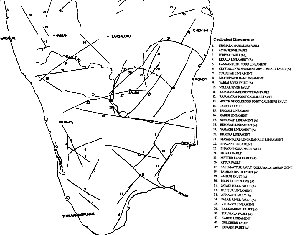
Kaveri is no exception to this. As per study based on GIS imaging, various Paleo Channels (A palaeochannel, is a remnant of an inactive river or stream channel that has been filled or buried by younger sediment) of the river Kaveri has been found to occupy Couvam-Korrataliyar basin, Palar, Manimutar, Agniyar -Ambuliar basin before moving into present day Kaveri delta region.
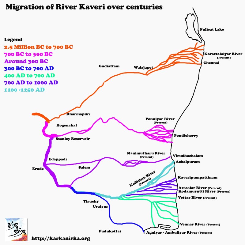
History of Kaveri migration below:
Pleistocene (2.5 M BC to 9000 BC) to Around 700 BC
Paleo Channels imaged through GIS show that Kaveri river met present day Palar channel and flowed in North Easterly direction from the Hogenakkal via Chinnar. Palakodu, Mattur, Tiruppathur , Gudiyatham , Vellore and Walajapet to meet the sea at Madras. Around 700 BC Kaveri abandoned this course. Today Covum, Adayar, Koratalayar, Kosthalaiyar flow in this basin which was once occupied by Kaveri and later by Palar.
Around 700 BC to 300 BC
From 2700 to 2300 years B.P. (Before present) Kaveri changed its track from a North easterly flow to an easterly flow via Uthangarai and Tirukovilur to meet the Bay of Bengal near Pondicherry. Today Ponnaiyar is flowing in the region and place it meets the Bay of Bengal is popular beach resort spot in Pondicherry.
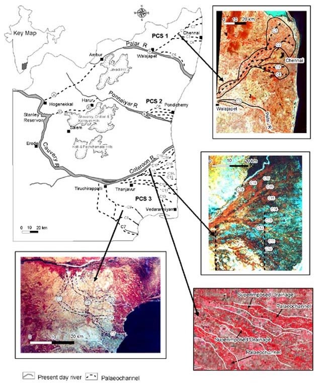
palaeochannels of PCS-3 in Tiruchirappalli–Pudukottai region, respectively superimposed by Vellar, Ambuliyar and Agniyar rivers; d, IRS FCC imagery showing palaeochannels C10 to C19 of PCS-3 currently occupied by Pamaniyar, Vennar, Vettar, Krittamanar, Arasalar,
Kudamurutiar, Palam Cauvery, Palavar and Manniyar rivers; e, IRS FCC imagery showing the superimposed drainage.
Source: Radiocarbon dating of some palaeochannels in Tamil Nadu and their significance – S.M.Ramasamy
Around 300 BC
Kaveri flowed east from Edapadi and Salem to meet the sea at Virudhachalam. Present day Manimuthar uses these tracks to flow throguh tot the sea. Accurate dating of this diversion is not known.
Around 300 BC to 700 BC
From 2300 to 1300 year B.P. it Kaveri flowed via Erode, Tirulcampuliyur,
Alagarai, Tiruchy, Kiranur and Pudukottai meeting the sea in the region where the present-day Agniyar and Ambuliar (South East of Pudukottai) meet the sea.
Around 400 AD to 1000 AD
Between 1600-1300 years B.P. the Kaveri flowed along the present-day tract of the Vennar and Vettar. After that Kaveri seems to have flowed as the Kodamurutti, Arasalar and Palanlcaveri from 1300 to 1000 years
B.P. (700 AD to 1000AD).
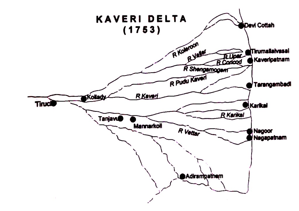
Around 500 AD Kollidam tract is used by Kaveri as flooding channel to drain off excess water.
Around 1100 AD to 1250 AD
From about 1100 AD. it flowed via Tirupurambiyam, Achalpuram
till around 1250 AD Kaveri streams stabilised as the Kollidam.
Kaveripattinam/Puhar Question
Kaveri had an anticlockwise rotational migration from the Agniar-Ambuliyar into the present-day Kollidam, old channels found south of the Kollidam are dated to around 1100 AD. Only mystery here is that if there was anticlocwise migration howcome Kaveri pattinam existed as major port town without access to river. Did any other channel exists in Kaveri pattinam from 3BC to 7th century AD or was Kaveripumpattinam was purely a port town with natural inlet for the ships to dock?
This question needs further study and S.M.Ramaswamy suggests that there could have been Proto – Amaravati river flowing between Uriayur and Kaveripattinam before Kaveri took over the over this Channel. Possibly this could have been reason for ancient name of Puhar and name change to Kaveripattinam in a later date after arrival of Kaveri.
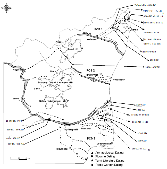
Payampalli (6) Tirukkambuliyur (7), Alagarai (8), Woraiyur (9), Tiruvidaimarudur (10), Kudamurutiar (11), Senaganur (12), Thalaignayar (13),
Coleroon (14). Pallipalayam (15), Pudupakkam (16), West of Ennore (17), West of Pudupakkam (18a, 18b and 19a, 19b), Kolappacheri (20),
Manachanallur (21), Srivanjiam (22), Malliyam (23), Kaveripoompattinam (24) PCS 1 to PCS 3 Palaeo Channel Systems (1 to 3).
Source: Radiocarbon dating of some palaeochannels in Tamil Nadu and their significance – S.M.Ramasamy
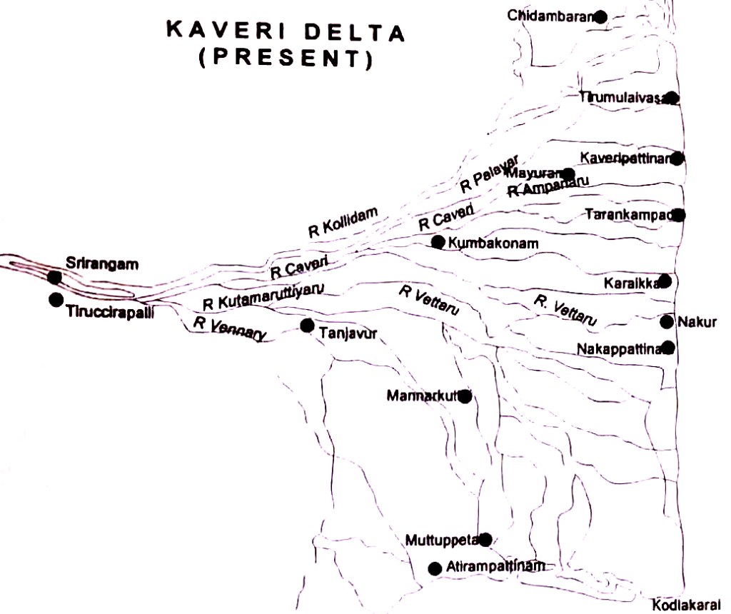
From 18th century
Kaveri continuously keeps changing tracks both North and South in the delta region.
Next post – Civilization of Kaveri
Kaveri being such important river should have enabled civilizations in Tamil Nadu. This search led me to finding out sites which could have been part of Ancient Kaveri delta in and around Chennai. I am currently studying research papers on this topic. My next post would cover these civilizations which could shake our very understanding of Human evolution in India.
Reference:
The Phenomenon of River Migration in Northern Tamil Nadu
-Evidence from Satellite Data, Archaeology and Tamil Literature by
M. Ramasamy. V. Venlcatasubramanian, S. Riaz Abdullah and S. Balaji
Radiocarbon dating of some palaeochannels in Tamil Nadu and their significance – S.M.Ramasamy
Navigation Environment of Ancient and Medieval Ports of Tamilaham – B.Arunachalam
Maritime heritage southern Indian Penninsula – B. Arunachalam

Scientificaly explained and geologicaly plausible arguments.
A geologicaly feasible reasons.